Firefighters in America have started to use cloud computer and data in an attempt to handle emergencies better. Social Media and Geographical Information Systems are just some of the ways they are using technology to more effectively fight fire. In an emergency, time is of the essence so by using computerised systems they can then respond more effectively to the any situation.
“If managed well, prevention and mitigation can not only help communities reduce response times, but can also significantly impact the effectiveness of the responses in terms of getting the right resources to the right place in the most timely manner,” says Jennifer Schottke, a fire and emergency services specialist at mapping software company Esri.
“By reducing the number of preventable incidents and managing the response to unnecessary or inappropriate calls (i.e. repetitive false alarms), a community can much more efficiently and effectively support the rapid and full-scale response required for a large and dangerous event,” she adds.
The Wall Street Journal claims that New York Departments have been using Data mining Programmes since July. Almost like a scene out of the hit Television show \’Numbers\’, they have started using algorithms to predict areas who are most at risk from fire and should be inspected more often. The algorithm is based around statistics that show areas with lower income are more susceptible to fire hazards.
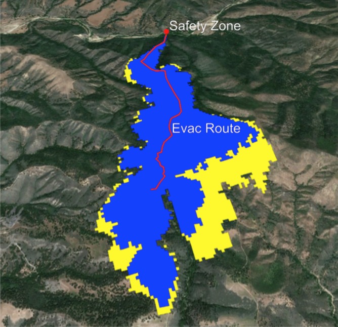
Surrey in British Columbia Canada set up a programme two years ago exploring the introduction of Personalised fire prevention education to areas that have higher number of home fires especially amongst the elderly, young and poorer residents. They relied on GIS to map targeted and non-targeted mapped areas. At the end of the two years they discovered a reduction in home fires in the areas that received fire prevention packages.Australia uses social media and GIS to more accurately respond to search and rescue situations.
The chief uses these ‘map stories’ to help the community stakeholders and public officials better understand the strategic policy decisions they are making and how they influence the department’s ability to meet community objectives for safety,” Schottke says. Oregon is currently building a data systems on areas that experience high levels of false alarms and how best to deal with them. This can also be used to predict trouble spot regions.
However according to The Wall Street Journal, these systems are still in their infancy and it\’s difficult to predict how effective they are in response times and in reducing fires.